| PP Saline groundwater in tidal basin | |
|---|---|
| Context | PP Ontpoldering Perkpolder |
| Type | Condition |
| Decompositie type | IOR |

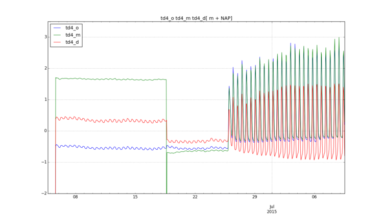
Figure 1: Time series of measured hydraulic heads at 3 different depths for location td4 (o= 3m, m=8m, d=12m) (Boersema et al. 2016).
In figure 1 the measured hydraulic head of location td4 (see Boersema et al. (2016) page 29) is presented for three different depths. Clearly visible is the moment of opening of the dike at 25th of June 2015 when salt water flooded the area for the first time and suddenly the hydraulic head increased as well the tidal fluctuation. Also visible is the decrease of the tidal fluctuation of the hydraulic head with depth, according to the expectations.
De View-Navigation (VN) pagina's.
De links naar andere pagina's.
| Onderdeel van | PP Groundwater processes |
|---|---|
| Instantie van | |
| Betreft |
Draagt bij aan.
| Draagt bij aan | PP Seepage of saline water |
|---|---|
| Waarde | + |
| Opmerkingen |
De pagina's die linken naar deze pagina.
Dit element heeft geen subelementen.
| Komt van | Type | Connectie type | Conditie | Waarde | Opmerkingen |
|---|---|---|---|---|---|
| PP Discharge inlet | Contributes | + |


