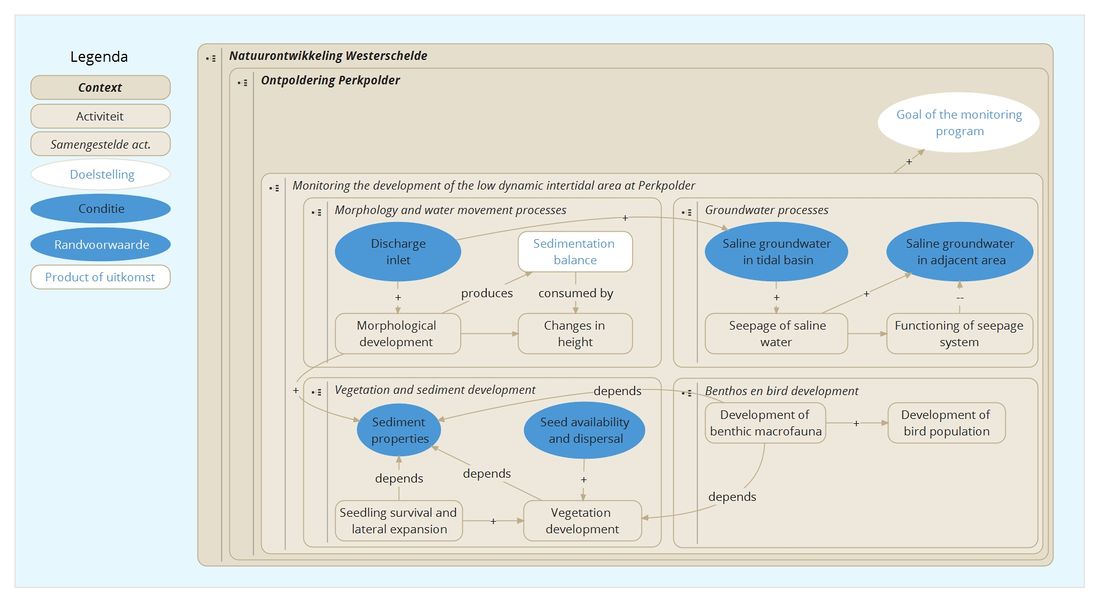
| PP Monitoring the development of the low dynamic intertidal area at Perkpolder | |
|---|---|
| Context | PP Ontpoldering Perkpolder |
| Decompositie type | IOR |

Introduction
Since June 25th 2015 the Perkpolder tidal basin is flooded twice a day by sea water from the Western Scheldt. The inflow of water has a direct impact on the erosion and sedimentation processes, which give rise to morphological changes. With the inflow of water benthic macro fauna will start colonizing the area and provide the food for birds. At some point in time the vegetation will change and will settle and increase the stability of the deposited sediment. In a three-year project (2016 to 2019) the Centre of Expertise Delta Technology (CoE-DT) has monitored the development of the area. The partners of CoE-DT in this project were: Rijkswaterstaat Sea and Delta, Deltares, Wageningen Marine Research, NIOZ Royal Netherlands Institute for Sea Research and HZ University of Applied Sciences. The research focused on the morphological and ecological developments and the groundwater changes in the Perkpolder tidal basin. In addition to developments inside the tidal basin, the effects of saline groundwater on the surrounding agricultural areas were investigated. To reduce the impact of saline water a unique seepage discharge system was constructed around the Perkpolder tidal basin at the landward side of the dyke. Deltares is investigating these effects and the functionality of the seepage discharge system. The monitoring and research plan of the seepage discharge system is described in De Louw (2014); the monitoring and research in the Perkpolder tidal basin is described in Boersema et al. (2015). The data and the methods that have been used for the evaluation of the monitoring program are all described in the Perkpolder progress report (Boersema et al. 2016). The overall results are listed in final report (Van de Lageweg et al. 2019).
Problem statement
Rijkswaterstaat bears the responsibility to realize a new tidal environment at Perkpolder (NCW-eindrapportage, 2008). The goal is to create 75 hectares of low-dynamic tidal nature due to the fact that the habitat has disappeared in the Western Scheldt over the last century as caused by human interference in the Scheldt estuary. In addition, this project provides a unique opportunity to monitor and study the biotic and abiotic changes in an area, that transforms from a freshwater agricultural area into a tidal salt-water natural area. This transition hasn’t been studied much, thus knowledge is very valuable in respect to future tidal restoration projects.
Main conclusions
The main findings of the monitoring project are (Van de Lageweg et al. 2019):
- The morphological development of the Perkpolder basin and its contiguous areas slowed down in time. Regarding the inlet, the main changes took place within the first month after opening. The pond and the tidal flat areas were mainly accreting and the inlet and the foreshore area were mainly eroding due to the channel formation. The man-made creeks were filling up at the end (southern part of the basin) and eroding at the beginning (northern part of the basin) of the tidal flat;
- The sediment import varied strongly in time and sediment was also being exported for a number of tides. Over the 5 months of measurement data, the estimated net import was 13-16 kilotons, or 5000-6000 cubic meters of sediment excluding porosity;
- The seepage system was functioning well enough to compensate the effects of the new tidal area. SlimFlex measurements show no changes in the freshwater-saltwater transition three years after opening the area. Moreover, the seepage system can also be used to grow the freshwater lens by additional lowering of the hydraulic head during times of precipitation surplus;
- The vegetation monitoring shows that seedlings survive best in a well-drained soil without sediment dynamics. Yet, seedlings can tolerate some moderate sediment dynamics. They are more tolerant to accretion compared to erosion. Monitoring demonstrates that there is no seed limitation in Perkpolder. Artificially constructing drainage conditions or providing longer disturbance-free period could be an efficient management strategy to facilitate marsh restoration at early stages and shift in state from bare tidal flat to vegetated marsh;
- The development of the benthic community perspective is encouraging. A biologically active intertidal area has formed within a short time frame. Within three years, the benthic macro infaunal community shows a development towards a community found on natural tidal mudflats and is expected to reach a stable community in years rather than decades.

De View-Navigation (VN) pagina's.
De links naar andere pagina's.
| Produceert | |
|---|---|
| Consumeeert | |
| Onderdeel van | PP Planvorming uitvoering en monitoring ontpoldering Perkpolder |
| Instantie van | |
| Betreft |
Draagt bij aan.
| Draagt bij aan | PP Goal of the monitoring program |
|---|---|
| Waarde | + |
| Opmerkingen |
De pagina's die linken naar deze pagina.
| Bestaat uit | Type |
|---|---|
| PP Benthos en bird development | Activity |
| PP Groundwater processes | Activity |
| PP Morphology and water movement processes | Activity |
| PP Vegetation and sediment development | Activity |
| Komt van | Type | Connectie type | Conditie | Waarde | Opmerkingen |
|---|---|---|---|---|---|
| PP Planvorming en uitvoering | Connects | seq | |||
| Perkpolder Natuurcompensatie | Refers | deze pagina |