| PP Morphological development | |
|---|---|
| Context | PP Ontpoldering Perkpolder |
| Decompositie type | IOR |
Intertidal area

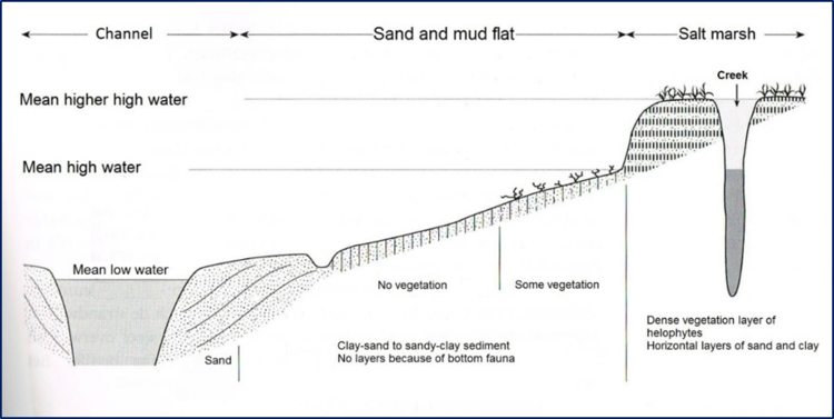
Figure 1 shows a typical composition of an intertidal area. The channels are defined below MLW (mean low water), the sand and mud flats or tidal flats are located between MLW and MHW (mean high water). The salt marshes are defined above MHW. The word ‘creek’ is not only used for tidal streams in the salt marsh, but also in the tidal flat.
Comparison with other basins

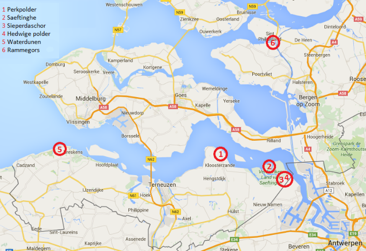
Figure 2 shows five tidal basins in the vicinity of Perkpolder, with some of them not yet open (Hertogin Hedwigepolder and Waterdunen). The basins vary in size and tidal range (Table 1). The calculated percentages of channels, tidal flats and salt marches are based on the definition that was mentioned earlier, and presented in Figure 1. Since this definition is only based on height levels, the bed levels of tidal creeks are added to the area of tidal flats, so tidal creeks are not recognized as separate morphological features.
Hypsometric curves have been used to calculate the percentage of channels, tidal flats and salt marches (Boersema et al. 2016 page 14). The high percentage of salt marches is seen in Saeftinghe (52%), Waterdune (63%) and Sieperdaschor (67.5%), which is an indication of a mature tidal basin. High coverage of tidal flats is an indication of relatively young basins, for example Perkpolder (88%) and Hedwigepolder (99%). The tidal range in Rammegors and Waterdune is much smaller because of a human-induced tempered tide. If Saeftinghe and Sieperdaschor are regarded as reference basins for Perkpolder, but at a later stage of the succession (from young to mature), it is clear from that Perkpolder tidal basin will undergo mature morphological changes if sediment import will not be a limiting factor.
| Tidal basin | Total area (ha) | MLW (m NAP) | MHW (m NAP) | Channel (%) | Tidal flat (%) | Salt marsh (%) |
|---|---|---|---|---|---|---|
| Perkpolder | 75 | -2,06 | 2,56 | 11 | 88 | 1 |
| Saefinghe | 2800 | -2,11 | 2,72 | 1 | 47 | 52 |
| Sieperdaschor | 100 | -2,11 | 2,72 | 0,5 | 32 | 67,5 |
| Hedwigepolder | 295 | -2,22* | 2,82* | 0 | 99 | 1 |
| Waterdunen | 250 | -0,55* | 0,55* | 17 | 20 | 63 |
| Rammegors | 142 | -0,20* | 1,40* | 4,5 | 72 | 23,5 |
De View-Navigation (VN) pagina's.
De links naar andere pagina's.
| Produceert | PP Sedimentation balance |
|---|---|
| Consumeeert | |
| Onderdeel van | PP Morphology and water movement processes |
| Instantie van | |
| Betreft |
Draagt bij aan.
| Draagt bij aan | PP Sediment properties |
|---|---|
| Waarde | + |
| Opmerkingen |
Connectie.
| Connectie type | seq |
|---|---|
| Connecteert naar | PP Changes in height |
| Conditie | |
| Opmerkingen |
De pagina's die linken naar deze pagina.
Dit element heeft geen subelementen.
| Komt van | Type | Connectie type | Conditie | Waarde | Opmerkingen |
|---|---|---|---|---|---|
| PP Discharge inlet | Contributes | + |


